A global variable-resolution model helps meteorologists understand the hydrological cycle throughout the Tibetan Plateau
Because of the vast high-elevation land, with an average elevation of over 4km, the Tibetan Plateau (TP) is known as the world’s third pole. Its unique mid-latitude climate and elevation that provides a headwater area for many large Asiatic rivers allows the TP to play an important role in the water cycle and regional ecology.
Throughout the TP, rainfall reaches its annual maximum in the summer primarily from moisture transport driven by the South Asian summer monsoon. The TP topography, particularly influenced by the Himalayas, is highly complex and contributes to unique rainfall patterns across the plateau. Because of this terrain, numerical weather and climate model should simulate water cycle process with a spatial resolution of a few kilometers so that the topography can be accurately accounted.
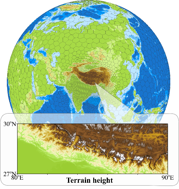
Fig. 1. The unstructured grid of a global variable-resolution model including the complex terrain around the Tibetan Plateau and Himalayas (resolution of ~1 km)
Prof. Chun Zhao and his team—a group of researchers at the Laboratory of Advanced Computing for Atmospheric Research (LACAR) within the University of Science and Technology of China (USTC)— conducted numerical experiments with regional refinement over the TP at a 4km horizontal resolution using a non-hydrostatic global variable-resolution model. This allowed the team to investigate the impacts of complex topography on TP moisture transport and precipitation during summer for the first time. Advances of Atmospheric Sciences has published the results of the study.
“Our study shows that global variable-resolution simulation at a few kilometers can reproduce the key meteorological fields over the TP in summer.” said Prof. Zhao, the study’s corresponding author. “Complex topography increases the net moisture transport into the TP by approximately 11% and significantly modulates the spatial distributions of precipitation over the Himalayas.
Dr. Zhao remarked that despite the regional changes in simulated rainfall distribution, when considering the average precipitation across the whole TP, the resolved topography leads to a negligible simulation difference compared to coarse spatial resolution topography. However, the new insights regarding modeling the influence of individual topography features are highly beneficial.
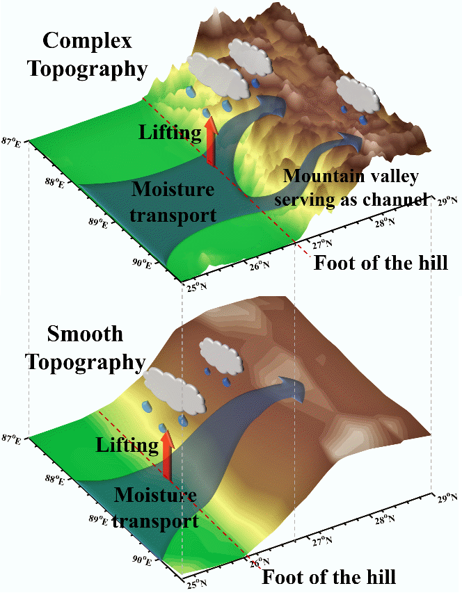
Fig. 2. Impacts of the Himalayas’ topographic complexity on the moisture transport and precipitation across the Tibetan Plateau during summer, compared to the smooth estimated topography from coarse spatial resolution models.
“Previous studies mainly conducted limited-area simulations at high spatial resolution using regional models, which may not fully simulate the impacts of complex topography on the large-scale circulation and hence the moisture transport.” said Prof. Zhao. “…the impacts are limited due to the constraint of lateral (horizontal) boundaries.
According to Prof. Zhao and his research team, the global variable-resolution simulation can avoid this problem, improving the ability to account for terrain influence on meteorological fields across the Himalayas and Tibetan Plateau.
“Compared to the smooth topography, with the complex topography, sharper southern slopes of the Himalayas shift the lifted airflow northward, and more small-scale valleys are resolved, which serve as channels for moisture transport.” said lead author Gudongze Li. “Both effects shift the precipitation northward.”
The global variable-resolution simulation approach appears promising for future weather and regional climate simulations throughout the TP. Forthcoming research will focus on applying the new method to water cycle, energy cycle, and atmospheric environment studies across the TP, including the topographic impacts on regional climate and air quality.
This research was supported by the National Natural Science Foundation of China NSFC, the USTC Research Funds of the Double First-Class Initiative, and the Strategic Priority Research Program of the Chinese Academy of Sciences. The study used the computing resources from the High-Performance Computing Center of the University of Science and Technology of China (USTC) and the TH-2 of the National Supercomputer Center in Guangzhou (NSCC-GZ).
Citation: Li, G. D. Z., H. M. Chen, M. Y. Xu, C. Zhao, L. Zhong, R. Li, Y. F. Fu, and Y. H. Gao, 2022: Impacts of topographical complexity on modeling moisture transport and precipitation over the Tibetan Plateau in summer. Adv. Atmos. Sci.,https://doi.org/10.1007/s00376-022-1409-7.
供稿:李顾东泽
地球和空间科学学院